

With a frequency below 20Hz, Infrasound wave can propagate a long distance of hundreds, even thousands of kilometers, because of its little attenuation. Many nature disasters such as earthquake, tsunami, volcanic eruption, and human motion such as high-speed rail, launching and state change of rocket may produce infrasound waves. Hence, obtaining the location and property of these events by studying on infrasound waves from these events has been an effective way to monitor the nature disasters’ happening and developing.
However, the truth that infrasound waves would be seriously affected by meteorological environment, such as wind and temperature variation at different altitudes, causes big errors of source localization and property analysis. Therefore, the influence of infrasound propagation has to be taken into account for reducing the error.
Based on a three-dimensional Hamiltonian ray tracing program in spherical coordinates, the effective sound speed was confirmed as the determining factor that influenced the infrasound propagation path.
Researchers from the Institute of Acoustics of the Chinese Academy of Sciences (IACAS) proposed an algorithm of infrasonic source altitude localization, and established a theoretical infrasound ray tracing propagation model for the back-projected infrasound propagation trajectory.
The study has been published in The Journal of the Acoustical Society of America in June 2019.
In the research, the mass spectrometer incoherent scatter radar model (MSISE00) and horizontal wind model (HWM93) were first used to obtain the effective sound speed at different altitudes in summer and winter in Beijing. Then, the propagation paths generated by an infrasound source in Beijing were simulated with a conventional model. Some of the simulated rays were used to verify the back-projection model, and the verification had a high degree of coincidence with the simulation. Finally, researchers used an experiment to validate the back-projection model and the altitude localization essentially conformed to the true value, proving the feasibility of the ray tracing back-projection algorithm.
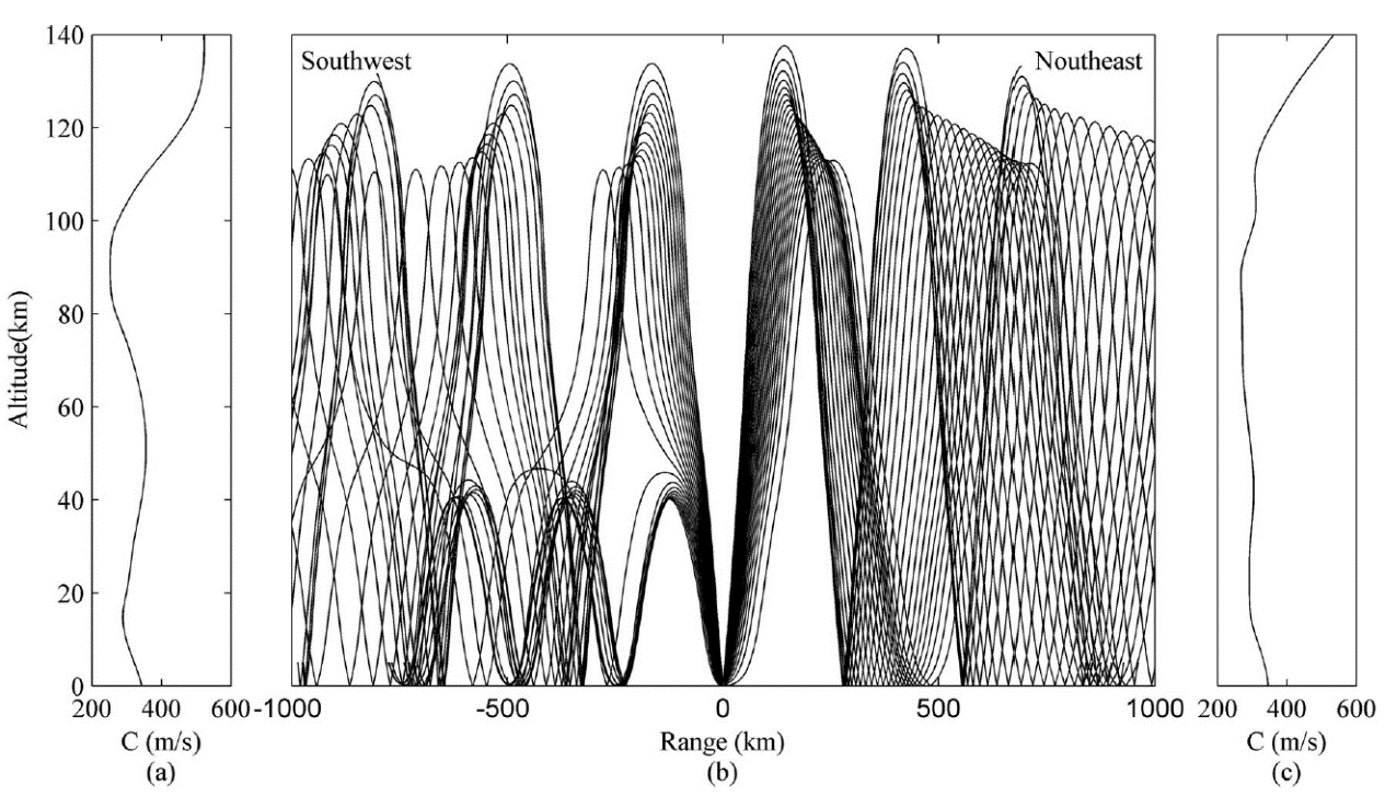
Figure1. Infrasound wave propagation path calculated by the HAPPA model (source height: 0; frequence: 0.1Hz; season: summer) (Image by IACAS)
This model included two key technologies. The first was ray tracing propagation model which was called HARPA (Hamiltonian Acoustic Ray-tracing Program for the Atmosphere). The model was a 3-D ray-tracing model which could be used to calculate infrasound wave propagation path by numerically integrating the Hamilton Function in spherical coordinates with considering wind and temperature profile in atmosphere.
The second was an inverse algorithm based on the HARPA model. The algorithm could be used to get the height of infrasound source by inversing receiving location and infrasound source. In the process, the wind model was the inversed wind field at the same propagation time.

Figure 2. A meteorite explosion location calculated by inversion algorithm of propagation path (Image by IACAS)
A meteorite exploded over Xilinguole League in Inner Mongolia at 04:13:30 on November 5, 2014, Beijing time. The explosion occurred at 43.1N, 115.8E, and the altitude was 22.2 km with the explosion location got by using the above algorithm. By comparing with the results reported by the NASA, calculated height error was 25.53% and location (latitude and longitude) error was 0.25o.
References:
SHANG Chuxiang, TENG Pengxiao, LYU Jun, YANG Jun, SUN Hongling, Infrasonic source altitude localization based on an infrasound ray tracing propagation model, The Journal of the Acoustical Society of America 145, 3805 (2019). DOI: 10.1121/1.5110712
Contact:
ZHOU Wenjia
Institute of Acoustics, Chinese Academy of Sciences, 100190 Beijing, China
E-mail: media@mail.ioa.ac.cn