As an important modern lifeline, the water supply network is closely connected to all aspects of our society, and the integrity of which provides essential services to production and residential life. To reduce the social, environmental and economic consequences, methods for effective and accurate detection and location of pipeline leakage are urgently required.
Acoustic methods could be applied to underground pipe network monitoring and leakage detection through measurements using acoustic/vibration sensors either installed along the pipeline or on the ground surface. Cross-correlation methods have been most widely used to detect and locate leaks in water supply pipelines. However, they are not applicable to multi-leakage detection.
Researchers from the Institute of Acoustics of the Chinese Academy of Sciences (IACAS) studied the dispersion and radiation characteristics of the leakage signals in water supply pipes. They proposed the acoustic method for locating buried pipes based on ground surface vibration measurements in earlier work.
Following the same principle, researchers found that the axisymmetric fluid-borne wave was the main carrier of acoustic energy at low frequencies, which could radiate and propagate to the ground surface once leakage occurs. The IACAS team with researchers from Tsinghua University carried out the experimental study of image fusion of ground surface vibration for mapping and locating underground pipeline leakage.
Researchers adopted tri-axial geophone sensor array to measure the ground surface vibration and extracted the magnitude information to determine the position of leak source. They also exploited the image fusion and incorporated it into the vibroacoustic technique to map the ground surface vibration, thereby demonstrating a feasible approach for remote sensing and locating multiple leaks.
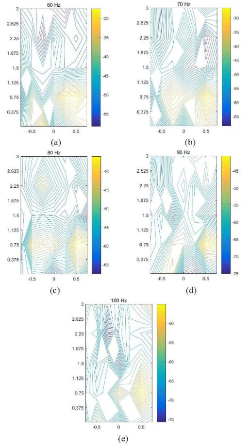
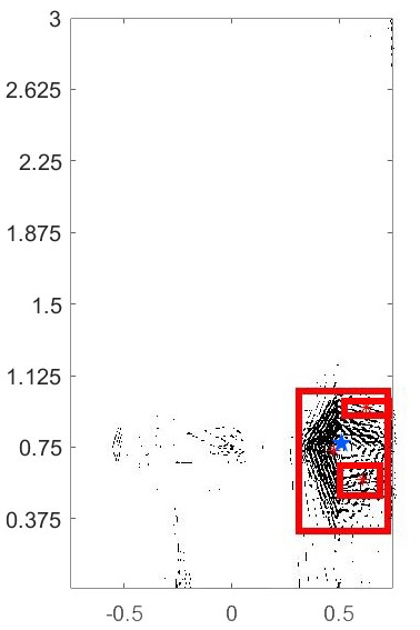
Magnitude contour plots were obtained by analyzing the characteristics of acoustic wave propagation of leak signals, as shown in Figure 1. The connected graph traversal method was subsequently introduced in the process of image fusion, revealing the suspected leakage area and leakage position, as illustrated in Figure 2.
The experimental results showed that the proposed method offered a potential improvement over the conventional vibroacoustic technique for automatically mapping and locating the suspected leakage area, which was beneficial to the practical application.
The research was funded by the National Natural Science Foundation of China (Grant No. 11774378), the Ministry of Science and Technology of the People's Republic of China, etc.
The research was published online in Sensors on March 29, 2020.

Figure. 1 Magnitude contour images of ground surface vibration measurements at different frequencies. (Image by IACAS)

Figure. 2 Determination of the suspected leakage area and leakage position (Red- suspected area; Blue-actual leakage position). (Image by IACAS)
Reference:
YAN Shuan, YUAN Hongyong, GAO Yan, JIN Boao, Jennifer M. Muggleton, DENG Lizheng. On image fusion of ground surface vibration signals for mapping and locating buried-pipeline leakage: an experimental investigation, Sensors 20, (2020), 1896. DOI: 10.3390/s20071896.
Contact:
ZHOU Wenjia
Institute of Acoustics, Chinese Academy of Sciences, 100190 Beijing, China
E-mail: media@mail.ioa.ac.cn


